Freshwater mussels in the West Cumbrian coalfield

saltom winding-house

The coalfield beneath the sea: view SW from above the Saltom winding-house

The late Norman Hammond once told me that he used to go out in his boat to count the basking sharks when they came into the Solway. One time, he was motoring off Fleswick Bay near Whitehaven during a coal-miners’ holiday; the men had been spending the day with their families on the beach, and one shouted across to him across the water.“I was asked if I could take them out to have a closer look, which I was glad to do,” Norman told me. “One man said he’d love to swim with them and I told him to slip over the side – off came his clothes and in the nude he swam with the sharks from Fleswick to St Bees’ Bay.”

Norman, who died in 2005, was the founder of Solway Shark Watch and he and his wife Florence were founder members of Cumbria Wildlife Trust. He was one of those rare people, so knowledgeable and enthusiastic about the natural history of the Solway that he wanted to share his knowledge with everyone. He was a story-teller – if you asked a simple question he would reply with such a wealth of information and anecdote that you became caught up in the tale. When he told me that one of the miners had given him a ‘freshwater mussel that he’d found in the mine’, that was a piece of information to remember and treasure.

So I immediately thought of Norman when geologist Eric Gozlan mentioned ‘musselbeds’ during his talk to the Cumberland Geological Society about West Cumbria Mining’s plans.
West Cumbria Mining (WCM) are exploring the West Cumbrian coalfields beneath the Solway Firth to the South-West of Whitehaven, with the view to extracting coking-coal (there’s a fuller discussion of the background, drilling and future plans elsewhere in this blog). An enormous amount of relevant geological data already exists but, as Eric pointed out, there is a considerable amount of faulting in the coal-field – in other words, there have been upheavals and slippage so that a band of coal and the rocks that sandwich it might have dropped several metres relative to their main position. Understanding the depth and extent of any fault is obviously important – there’s no point trying to carry on mining a band of coal if it has been pushed aside by a fault.

coal-seam-sequence-1-wcm-website

Stratigraphy diagram from WCM’s website

So, to map the coal-bands in three dimensions, it is necessary to drill bore-holes at different locations and extract cores. By knowing the depth of each rock-type on the core, it’s then possible to fit this information to the corresponding data from other cores and plot the extent and depth of the coal seam.

As Eric said during his talk, “The exploration geologist is always trying to find out where he is.”

eric1 crop

Eric Gozlan in WCM’s wooden office inside the warehouse

And one way he (or she) can navigate down through the rocks is by looking for specific markers of geological time. That’s where the fossil musselbeds become so important.
Knowing of my interest in the mussels from the mines, Eric had generously suggested that I come and visit the office to look at the cores. I met him and his colleague Steve Craig in mid-February at WCM’s office and ‘core store’ in Whitehaven. Their office is located within an airy warehouse adjoining a garage on an industrial estate – it was cold both outside and inside, and the heating was turned up high.

Eric has been leading WCM’s exploration project since September 2014; he has a Master’s Degree in Geophysics and Geology from Monash University, Melbourne and before joining the WCM team already had 10 years’ experience working in the mining industry. Stephen, who has a Master’s in Geochemistry from Leeds and is WCM’s site geologist, formerly worked in the goldfields of Western Australia. Within minutes of my arrival, they were both scurrying round, looking for technical papers for me and photocopying charts.

coal strat bgs

Taken from the BGS Memoir for the west Cumbria district (page 60)

The most useful chart is from the British Geological Society’s Memoir for West Cumbria [1], which shows the two main musselbands, one marine, one freshwater. Eric told me that the Vanderbeckei band – its local name is the Solway Band – ‘extends from Moscow to America’ and it is the ‘target boundary’ between the Middle and Lower Coal Measures that they look for in the core, identifiable by its fossil marine fauna such as the brachiopod Lingula.Then they search for other recognisable features.

‘We crack open the cores and look for freshwater mussels. Within the next ten to fifteen metres we should then typically find Yard Band, which is a good unfaulted band. Though it can be less than five metres depending on the [nearby] faulting,’ Eric said. Above the freshwater mussel band are Main Band and Bannock Band, both coal seams that are of interest to WCM.

Steve explained that there are as many as 20 different species of freshwater mussel fossils that are diagnostic of the depth of strata and the proximity of coalbands; or, as the BGS Memoir puts it, rather more euphoniously, ‘Palaeontological study of marine and nonmarine fossils has provided a chronostratigraphical framework for the coalfield.’

Eric and I go out into the core-store where metal shelves are stacked high with plastic core trays; black or mottled or wrapped in paper, the cylindrical cores are labelled with letters and numbers to identify their place and depth of origin.

The next batch of offshore drilling will start again in spring/summer 2016. ‘We will get tighter information on the kind of coalfield we’re going to intersect,’ Eric said, ‘– for example for the Sixquarter. We’re drilling to identify specific targets.’ Two drilling rigs will be running for up to six months – with two more geologists joining the current team of four.

He gives me a section of a core that has been varnished to show the freshwater fossils more clearly: there are two very obvious bivalve shells embedded in the rock – Steve says they are probably the mussel Anthracomya. Carbonicola (the only species whose name I knew) is older, found lower down. Two other sections of core show fragments of marine fossils, of the brachiopod Lingula and a couple of graptolites.

Seeing those fossils – marine fossils, freshwater fossils – in situ in rock that has been brought up from 400-500 metres below the seabed of the Solway, is extraordinary. It’s too easy to become blasé about fossils, there are boxes of them in museums and private collections. But these Anthracomya, whose fossil shells I could stroke with my finger,  were living, growing and filter-feeding on the bed of a river perhaps 300 million years ago.

That river ran across land that had previously, on occasions separated by tens of thousands, even millions of years, been submerged beneath the sea. The river delta had itself been inundated by the sea much later, on widely-separated occasions. That competition between sea and land had been carried out over millions of years; the climate had swung between tropical and temperate and glacial; the place those swamps and sediments and rocks occupied on the surface of our planet had drifted and been pushed through different latitudes and longitudes across the planet.

Norman Hammond would surely have had a good story to tell about that.

[1] British Geological Survey: Geology of the west Cumbria district, Sheet Memoir 28, 37& 47. NERC 1997

Posted in coal, fossils, industrial heritage, sea-bed & undersea, shells | Tagged , , , | Comments Off on Freshwater mussels in the West Cumbrian coalfield

What’s been happening at Robin Rigg? An update

robin rigg

The distant wind-turbines of Robin Rigg, seen from the Allonby shore

Live shipping maps – watching vessels move around the seaways in real-time – can become addictive. I can easily be distracted by Danny Ferris’s Solway Shipping website with its live coverage, photos and notices of the ships that are due into the ports of Workington and Silloth.
During the past months there have been plenty of opportunities to be distracted, with considerable activity around E.ON’s Robin Rigg Wind Farm in the Solway, including much coming and going of E.ON’s own boats, Solway Spirit and Solway Challenger, and several other twin-hulled boats belonging to Turbine Transfers. There was also the unmissable presence of the massive jack-up barge MPI Adventure.

I first wrote about Robin Rigg in Cumbria Life in 2011, a year after it came into full operation, and I also spent several very amusing hours with the crews of the two service boats, Solway Spirit and Windcat 3.

Since then, there have been several changes. Tim Morgan became Plant Manager for Robin Rigg in 2013; a former materials engineer, he tells me he has ‘been in wind’ since 2004, both onshore and offshore. He kindly agreed to give me an update on Robin Rigg – especially since I assured him that I think the offshore windfarm is (unlike the piecemeal onshore scatterings of turbines) a handsome and efficient addition to the Firth. There are several important changes he’d like to tell me about, and I have several questions to ask. Our conversation at E.ON’s building at the Port of Workington is relaxed and informative – within the bounds of what he is permitted to discuss (as with my previous articles about Robin Rigg, I knew boundaries would exist and respect them.)

Offshore Maintenance teams
The Danish firm Vestas built and supplied the turbines, but Tim tells me that when their five-year maintenance contract came to an end in December 2014, E.ON decided to bring the whole offshore maintenance team in-house from January 2015, creating 12 permanent jobs for local people. ‘The in-house approach is working really well,’ he said, ‘and we’re becoming a close-knit team.’

Specialist teams have also had to be hired in the short term to do a ‘health check’ on the turbine blades, and subsequently some repainting and minor repairs; the work involved a special expertise, abseiling and rope-work high above the sea.

(Photos with permission from Alpha Offshore)

The service vessels have also been busy, due to around 40 maintenance staff working over the last 18 months, on an industry-wide issue with grouting inside the foundations.

So, what is grouting?

The design of an offshore turbine is actually fairly simple – basically the monopile base is hammered into the sea-bed; then a cylindrical Transition Piece (TP) is lowered onto the monopile and levelled. The 80-metre tower is bolted to the TP, and eventually the nacelle, blades, generators and so on, are installed at the top of the tower.
The TP is like a collar over the top of the monopile, and it is fixed in place by a special sort of cement-like substance, the grout; the grout is thus essentially a loaded component, carrying the weight of the turbine.

It became apparent at several wind farms that there were weaknesses in the grouted connection, and checks on the turbines at Robin Rigg showed up weaknesses in the design.

Court-Rules-Against-MT-Højgaard-for-Robin-Rigg-Work

The tower sits on the (yellow) TP – and the turbines offer a perch for increasing numbers of cormorants (photo with thanks to E.ON)

Tim explains that the ‘remediation work’ to safeguard the site against any longer term problems was estimated to take around two years’ work; it is well under way and can be carried out inside each turbine foundation (a surprisingly large space, 4.5 metres in diameter).

A decision to find where the responsibility for the incorrect ‘design code’ lies is ongoing. In April 2014, MT Hojgaard (MTH), the company responsible for undertaking the grouting work, was taken to the High Court by E.ON and found liable for damages.
MTH appealed the decision at the Court of Appeal in April 2015, arguing that it had ‘observed the applicable international standard as required by the client’ – and won: it was ruled to be not liable for the remediation costs.
In November 2015 E.ON took the case to the highest legal authority, the UK Supreme Court – and has recently been granted the right to appeal.

Meanwhile, remediation continues inside Robin Rigg’s foundations.

Service vessels: operations, maintenance, and decommissioning

The maintenance technicians, rope-access teams and others are ferried between the wind farm and the Port of Workington by the service boats. E.ON commissioned their second vessel in October 2013; one of the pupils at Northside Primary School in Workington won a competition to choose the name, the Solway Challenger, and the vessel was blessed and named at a special ceremony at the Port. Solway Challenger is a twin-hulled, 19-metre vessel, and with her twin-deck wheelhouse is “very comfortable and spacious”, Tim assures me.

eon boats2

Twin-hulled Turbine Transfers’ O&M vessels at the Port of Workington

Windcat3 is no longer on site, but other Operations and Maintenance (O&M) vessels are contracted to E.ON on a varying time-scale. Turbine Transfers has had several vessels working in the area, such as Port Wen, Rhoscolyn Head, Porth Diana, Aberdaron and Lynas Point (you might have guessed that it’s a company based in Wales). The grey twin-hulls are especially designed to enable them (like Windcat before them) to nose up to a turbine and allow people and kit to be transferred despite the swell. O&M is keeping crews and vessels busy.

The jack-up vessel, MPI Adventure (a newer design than MPI Resolution which put the monopiles in place) steamed onto the scene on October 2nd 2015. She is contracted to E.ON, and Tim says she arrived following work on a project in the German North Sea. The Solway’s weather was very changeable and often wild during the autumn and “although Adventure’s stable when the legs are down, you can’t be using cranes and so on in high winds”– so whenever the wind got up, Adventure paused or headed back to Belfast until the working window of the next Neap tide.

I watched from the Senhouse Roman Museum at Maryport in November on one occasion when she returned, and she was an imposing sight, travelling fast for such a giant.

mpi adventure from eddie s

MPI Adventure at Robin Rigg (partly removed turbine to the left). My thanks to Eddie Studholme for this fine photo.

Why was she at Robin Rigg? To decommission  two of the turbines, A1 and B1: in other words, to take them down. Tim explained, “After the storms of winter 2013/14 there was an effect on the channel causing it to move. We made a proactive decision to take out the two turbines after monitoring the movement of the sandbank and loss of seabed.”

Generation by these two turbines was halted back in April 2015; they were dismantled in October. There is no impact on the remaining turbines at the wind farm.

Artificial reefs

I’ve written elsewhere about Natural Power’s drop-down video survey of the monopiles, and the clusters of mussels, brittlestars, sea-anemones that have found a foothold on their surfaces, on some of the few places in the Firth where there is a firm substratum.

Offshore wind farms provide discrete artificial reefs, a specialist niche which might also be supposed to provide food and shelter for some species of fish.

It was interesting, therefore, to hear that one of the monopiles removed by MPI Adventure was encrusted with organisms; the photo shows what an astonishing biomass of marine organisms have attached and grown on the base of the turbine, forming a dense and interconnected ecosystem.

encrusted base from Tim M rsz wmk

A turbine base removed from the sea, densely encrusted with marine organisms (I’m grateful to E.ON for this photo)

The Solway’s shifting sands

The Solway Firth is “raw and beautiful” according to Tim Morgan; he also called it “chaotic and unpredictable.” Colin Sharpe, Development Manager at the Port of Workington calls it “one of the most aggressive estuaries in the UK.” Marine biologists at Natural Power refer to the Solway as a ‘highly dynamic estuarine environment.’

It is infamous for its shifting sands and channels, its changing bathymetry and sedimentation. In the region of the wind farm, the seabed is in fact a series of banks (Dumroof Bank, Robin Rigg, Two Feet Bank and Three Fathoms Bank) orientated in a northeast – southwest direction. Here, according to a bathymetric survey (see note 2 for weblink) there are ‘finer grained granular sediments … ranging from laminated sands, silts and clays to organic silts and clays.’ Across the whole of the turbine array area sediments ‘generally comprise mobile, shelly fine to medium grained sands’.

RR water depths from combie report

From COWRIE report

When Natural Power ecologists Jane Lancaster and Fraser Malcolm carried out surveys of fish and benthic invertebrate fauna during the pre-construction, construction and operational periods, their ‘baseline survey sampling locations were selected, through consultation with local fishermen, to maximise catch by following the channels adjacent to the sand banks within the study area. Subsequent surveys during the Construction and Operational periods were conducted at the same survey locations in accordance with the MEMP [Marine Environmental Monitoring Programme]. However, as the Solway Firth is a mobile sand bank system influenced by tidal currents, the original sandbanks surveyed in 2001 had shifted by the commencement of the construction period surveys.[1]

I see the offshore wind farm as a compact and coherent way to harness the wind’s power, one of the forms of ‘renewables’ that we must have in the UK’s portfolio. That 60 wind-turbines and two transformer stations could be built in the adverse conditions that are so much a part of the Solway’s ‘character’ is a major triumph of engineering and persistence. And while many people might enjoy the schadenfreude of perceived difficulties with the windfarm, that ‘I told you so’ moment, there are good things to report. Last year, according to their newsletter Round Robin, ‘Turbine availability reached over 97% during this time, which is an industry leading performance level’

***

However, with regard to the difficult environment that the Firth presents, the proposers and architects of other forms of renewable energy related to the Firth should pause in their rush to create over-large schemes, and consider very carefully what the Solway can throw at them: and then design accordingly.


Note: I met with Tim Morgan in November 2015, and he submitted my draft blog-post to E.ON’s communications and legal teams in early December 2015 for consultation and approval. I received this, their edited (and sixth) version, on February 19th 2016 – hence the delay in its publication.

[1] p49, Chapter 2, Migratory Fish, in Analysis of the Marine Ecological Monitoring Programme Data for the Robin Rigg Offshore Windfarm, Scotland (Operational Year 3), EOn Climate & Renewables; http://www.gov.scot/Resource/0046/00463655.pdf )

[2] Bathymetric survey, COWRIE report https://www.researchgate.net/publication/267221965_A_Further_Review_of_Sediment_Monitoring_Data; see section5.2 for Robin Rigg)

Posted in renewable energy, tide & wind, ships | Tagged , , | Comments Off on What’s been happening at Robin Rigg? An update

From ‘killing field’ to wetland and woods: Watchtree Nature Reserve, Cumbria

From the hill at Watchtree Nature Reserve you can look across to the upper reaches of the Solway Firth, the Borders and, to the East, the Northern Fells. It’s early February and the snow-coated top of Skiddaw is glistening  in the sun; a skylark is singing, and the clutter of tree-sparrows squabbling in a hedge are momentarily silenced as a sparrowhawk sweeps through.

Frank Mawby, a Director of the Reserve’s Trust (and former Reserves Manager for Natural England in this area) drives along the runway to meet me; he has been organising the volunteer work-party. He tells me he’d like to get some funding to build a tree-top hide ‘so that people can see where we are in relation to the Firth.’

Ideas and plans and optimism about the future – these have always characterised the development of Watchtree, right from its inception. I came here in 2011, on the tenth anniversary of the Foot-and-Mouth (FMD) epidemic that swept through Cumbria and now, on the fifteenth anniversary, I have come back again to see how the Nature Reserve has progressed since then.

Watchtree is on the site of one of the Solway’s several wartime airfields, Great Orton, which, abandoned after the War, became an unofficial ‘community resource’ used by microlite flyers, clay-pigeon shooters and youngsters learning to drive.
But then, in February 2001, it was commandeered as a mass grave, an enormous engineering and logistical feat that saw 26 burial ‘cells’ dug – and filled. The name, Great Orton, became synonymous with ‘the killing field’, the great trauma of the county, which many find hard to talk about even today.
There is a plaque at the gate, mounted on a piece of Criffel granite, a glacial erratic that was dug up nearby:

“A Symbol. To the birth of Watchtree Nature Reserve, dedicated this day the 7th May 2003, the second anniversary of the final burial.
A Memorial. To 448,508 sheep, 12,085 cattle, 5,719 pigs buried here during the Foot and Mouth outbreak of 2001″

memorial stone2 rsz

Half-a-million animals; so few infected. This is not the time or place to dwell on the impact of the disease, but you can read a fictional account (based on fact) of what happened to Madeleine, a Herdwick sheep-farmer, in this extract (page 20, Firecrane) from my novel, The Embalmer’s Book of Recipes.

But now, one can almost forget what lies beneath the wildflower meadows, the woods and the lagoons.

Next to a hide overlooking a pond, Frank opens a wooden door in a fence (this requires some spectacular contortions as the clasp is on the far side) and takes me into a grassy, scrubby, wetland area by the four lagoons. These lagoons are ‘operational’ and not open to the public; the richness of the surroundings is breath-taking even at this wintry time of year – the common reed Phragmites and bulrushes Typha latifolia fringe the water; the leaves of yellow flag and golden-cup are starting to show at the edges. A teal takes off, and then three snipe, zig-zagging with flickering wing-beats. Willow and birch are growing along the sloping banks, and Frank shows me how they are coppiced on different sides each year. There is gorse, too – as always, some of it in flower (‘When the gorse is not in flower, then kissing’s not in season‘).

The still water reflects the blue sky and slowly-moving clouds. ‘It’s very clean water, and biologically it’s got an awful lot growing in it,’ Frank tells me. ‘We get Great Crested Newts, tadpoles, dragonfly and damselfly nymphs. And Great Diving Beetles – though they’re mainly in the main lake. They’re voracious predators, they’ll even clean out the tadpoles.’
As for the birds that have been seen around the lagoons, ‘We’ve had sedge- and reed-warblers – they were a surprise. Six or eight pairs of linnets, goldfinches, willow warblers – and the usual dunnock, wren, robin. Coot, moorhen, Little Grebe. Reed bunting. White-throat. And swallows love it here, feeding over the surface.’

To understand why there are wetlands and lagoons here, on a former airfield, you have to understand what happened during 2001. If you stand by the gate and look along the western runway it’s impossible to ignore what lies underground. There are regularly-spaced green metal boxes and metal cowls and the ends of pipes. Part-hidden in the wood at the northern end are the buildings, with humming machinery and computerised read-outs from the biodigester plant where the contaminated liquid from the burial cells is processed. ‘Leachate’ became part of our common vocabulary for several years after FMD; one estimate is that it could take 40-60 years to disappear.

‘The whole site is very complicated,’ Frank had explained to me in 2011. ‘We have to consult Interserve [the company contracted to oversee the drainage] and look at all the plans, especially when we’re digging ponds. There’s masses of electrical wiring as well as the drainage schemes.’ The whole burial area is lined by a wall of bentonite, a mix of clay and slurry that is 12 metres deep and pressure-driven into the bed-rock. There is a ring-drain within each cell, and leachate is pumped out of the cells to the biodigester where bacteria break it down. Drainage of the whole site is indeed complicated, in that surface water (from rain) is collected into ditches, where it joins with the deep ground-water and treated effluent, and is sent to the lagoons and reed-beds for the sediment to settle and excess nitrogen to be taken up and removed. ‘We’re at the top of a hill, so any water coming off must be absolutely pure – it’s tested at all stages, for ammonia, solids and pH.’

And also back in 2011, Frank had told me, ‘Although the waterbodies were created by us, everything in them is developing naturally, reeds are coming in and we should soon get reed-buntings. The Great-crested Newts wouldn’t be here if it wasn’t for us. And they’re going further afield, spreading and spreading every year.”

Now, five years on, the reed-beds are flourishing, and he can reel off the number of bird species and say, ‘It’s an amazing bird list!’

Nest-boxes, and bird-feeders with seeds and nuts, hang from some of the trees: ‘The tree-sparrows are doing well. They’ll clear out one of those feeders in a day. Visitors get a lot of pleasure seeing the birds’. We see a yellowhammer on a bird-feeder, and I remember that there had been hopes that they would breed on the Reserve. ‘They’re not yet breeding here – but the hedgerows are about right for them now, so hopefully we’ll see some nesting this year.’ And although the sandmartins are still resisting the invitation to nest in the artificial bank that was built for them, oyster-catchers nested on top of the bank instead.

What is Frank most pleased about? ‘Ah,’ he pauses and considers. ‘All things are doing reasonably well – the grasslands are difficult, but the wetlands have come on nicely, there are abundant birds on them. The lake attracts a lot of birdlife in winter too.’

lake3 feb16 rsz

The lake, seen from the hide

We climb the wooden steps to the hide overlooking the lake, and open the long windows to view the birds; the water is blue and scarcely ruffled by the biting wind, the reeds are pale and rustling. There are tufted duck and gadwall on the lake, a coot and a Little Grebe, and Frank is surprised to see that there are now four swans, one of them high up on the bank. ‘We had a big starling roost here a year ago.’ How many birds? ‘About 20, 000 – a good murmuration. But one night the lake froze and they went away the next day – perhaps they know that predators can get at them more easily when it’s frozen. But they’ll probably come back.’

From the hide I also see two humans, cycling along a tarmac-ed strip of runway towards the woodland. The ‘Watchtree Wheelers’, overseen by Ryan Dobson, were set up with £25,000 in Lottery Funding to provide a range of bicycles, tricycles and motorised wheelchair carriers, as well as a hard track around the Reserve,

watchtree bikes2 rsz

The Watchtree Wheelers

so that disadvantaged and disabled people might enjoy some ‘quiet recreation’ around the wood; this was the brain-child of another of the Trust’s Directors, Bill Knowles.

The soil
As on my previous visit, the quality of the soil is a topic of conversation. The soil has had a history of disturbance by men with diggers: during the War when the runways were built and in 2001 when the burial chambers were dug.
The clue that it varies from place to place is provided by the vegetation.
We walk down the edge of one of the old runways. The wind-turbines scythe rhythmically overhead. Overburden from the excavation of the burial chambers was laid along the runway and a ‘commercial mix’ of grass was seeded and grew well; but it out-competed the herbs, so Frank brought in haybales from a wildflower meadow and much of the seed they contained ‘took’. ‘It’s now one of our best wildflower meadows,’ he says, and brown hares are frequently seen there. The meadows are grazed in the autumn to stop the build-up of rank grasses – three local farmers bring in cattle and sheep to graze the different areas.
There’s another, newer, wildflower meadow beneath the fourth turbine, sheltered by a hawthorn hedge. ‘It takes time,’ Frank says. ‘It might take 50-60 years for it come right. But I’ve always said we should go for meadows rather than just plant more trees – planting more trees seems to be everyone’s answer these days! Wildflower meadows have been our biggest loss [in the countryside], so if we can make it work, in time it will be really valuable’.

Into the woods
We walk along along another runway, the date ‘28/4/42’ scratched in the cracked concrete, towards the woodlands: two patches of woodland had existed previously, and more than 80,000 trees have been planted to link them, a mixture of Scots pine to encourage the red squirrels, and broad-leaved trees like rowan, hazel, willow and grey poplar. There is a plantation of self-seeded alder, and as we walk along the trail the sunlight picks out the trunks of the birches where brush and saplings have been cut back to create a ‘woodland glade’ effect to encourage butterflies.Great Tits and Coal-tits flitter and chatter amongst the trees.
In one place the Scots pine and other saplings have not grown well: the soil is poor and compacted.

stunted growth feb16 rsz

‘The trees will quickly tell you if they don’t like the soil’

‘The killing-sheds were here,’ Frank tells me. ‘The trees will quickly tell you if they don’t like the soil.’

But some of the volunteers have dug holes in the hard pan, and these have filled with water – ‘transitional pools’, Frank calls them, where there are now three species of newt. ‘These areas of different soil, they’re creating structural diversity. We’ve got a range of habitats.’

This is what draws me to Watchtree, not only its size and its range – the mix of woodland, wetland and open water, scrub, wildflower meadow and rubbly, well-drained ground – but the unbounded optimism of Frank and everyone else I meet who is involved with the Reserve. The approach to this site has been empirical, experimental, and – as with all good science – there is a pragmatism and a willingness to understand what is going on, and to either build on the results or take a new approach.

We go through a gate into Pow Wood, where a student is standing by a camera on a tripod, waiting to capture an image of woodland birds. There are huge tree-stumps, draped with sumptuously mossy growth; there are lichens and fungi, and a mix of birch and alder and willow, with a little rowan and oak. ‘The trees were cut down by the Ministry [of Defence] during the war when this was an airfield. All this has regrown naturally.’ Brambles and saplings fill in gaps between the more established trees. ‘The woodlands have got to the stage they need thinning. That’s part of the Management Plan we’ve put forward – the volunteers can do some, but beyond a certain size we need contractors. We’re going to do some training in charcoal burning  with the thinner stuff – we’re thinking we could sell the charcoal to our visitors.’

The burial plots
The underground cells are lined up beneath the edges of another runway; although they are covered with vegetation the regularity of their outlines, and the green metal boxes and spinning, shimmering ventilation cowls mark their presence. Ten of the plots have been used over the past 10 years to trial various seed mixes. ‘It’s quite a challenge,’ Frank tells me – just as he told me five years ago. ‘It’s old glacial mineral soil, quite alkaline, pH 7.3. If you try to plough it, you’re turning up rocks and stones. It’s a wet heavy clay mix, and we’re having a problem with rushes starting to take over. About the only thing that will kill them is glyphosate and you have to apply that with dabbers. But we’ve sown a seed mix on them and we get self-heal, knapweed, a variety of grasses.’
Of the hand-planted Devil’s Bit Scabious – several thousand when I was last here – ‘hardly any have survived’, though some have self-seeded and are growing on the stony margins of the runway.

watchtree trial plot scabious2 rsz 2011

Wildflower plot with scabious, above a burial cell, 2011

Scabious are the food-plant of caterpillars of the Marsh Fritillary butterflies and, although no butterflies have yet established here, Watchtree’s annual Captive Breeding Programme is still ongoing, rearing the caterpillars in cages. The butterflies are then sent out to various donor sites – to Ennerdale as before, where ‘they’re doing well’, and more recently, to nearby Finlandrigg wood.

Where does the funding come from?
Last time I visited, DEFRA’s ten-year funding package was half-way through; it has now ended. This has meant a re-organisation of staffing – former Warden Tim Lawrence has left, leaving one full-time staff member and, for the present, two students working part-time in education and conservation. The Trust’s Directors have been very pro-active in seeking extra funding over the years and currently have a couple of projects proposals under review – a proposal to Cumbria Waste Management and the Community Fund for a compostable toilet at the far end of the reserve, and a large Woodland Management Plan proposal to the Forestry Commission.
At present, the Reserve’s income comes from several sources including the very popular Watchtree Wheelers, membership fees, donations, and the Café. By using volunteers in so much of the conservation work, it has been possible to put some money aside. The day of my visit, a Wednesday, there are two groups of volunteer helpers, with loppers and saws, cutting and laying hawthorn hedges. ‘We still have financial reserves,’ Frank says. ‘We’ve got three or four years to make up the difference between what we spend and what we need to keep going.’ As for the volunteers, ‘They get through an awful lot of work. We’ve got a nice little group at the moment. Mostly retired folk, but we get three or four years’ work out of them!’

As we walk back along the runway towards the smart visitor centre and Café an old tractor approaches and the driver, William Little, stops to chat to Frank. William is a retired local farmer who, as Chairman of Great Orton Parish Council during the Foot-and-Mouth crisis became involved with Watchtree Nature Reserve through the local liaison committee. He, like Frank and some of the other Trustees, has been working for the Reserve since its beginning.

Watchtree Farm, Great Orton airfield, Great Orton burial ground, Watchtree Nature Reserve: it’s a place of such mixed histories. Yet, as on my first visit, I am impressed at the spirit of optimism, of looking to the future, that continues to drive the Nature Reserve forward. It feels a happy place.
Last year it had 16,000 visitors: people coming to enjoy the views, the birds, the flowers, the varied scenery; people coming to use the Wheelers’ facility, to visit the Café, to volunteer; school-parties coming to dip ponds and learn about the countryside that they live in; and on the final Sunday of each month, an increasing number of runners coming to take part in the 5K run.Watchtree has become a symbol of diversification and biodiversity.

As William Little said in a television interview, ‘[The reserve] has turned what could have been a disaster for the local community into an asset’.


Useful information:
The Reserve’s  website has lots of information about events, volunteering, Watchtree Wheelers, contact details, map, and more.

A 2001 report on ‘The killing field of Cumbria’ and links to daily reports on the FMD epidemic of 2001

Posted in conservation, Foot-and-Mouth epidemic, wetlands | Tagged , , | Comments Off on From ‘killing field’ to wetland and woods: Watchtree Nature Reserve, Cumbria

Some things I didn’t know about sand-ripples and the sea

‘ ... the tide holds back from the flat wet sands / That darken from tawny to brown, where little pools / Are stranded like starfish in the rippling ribs’.  Norman Nicholson, The Bow in the Cloud

(I am grateful to Joe Dias for allowing me to use these images of his paintings)

There is a very low Spring tide and we’re setting off down the shore, a group of people, all ages. We cross a bank of shingle, chatting, asking those questions that are a preliminary to spending time with each other for a couple of hours: ‘Where do you live?’, ‘Do you know so-and-so?,’ ‘What’s your dog’s name?’

Then we go down onto the sand, an apparently featureless expanse that stretches down to the distant rocky scaurs. ‘It looks pretty flat and boring, doesn’t it?’ I say.

OLYMPUS DIGITAL CAMERA

Water-sculpted ‘waves’ of sand, and wind-sculpted dunes (photo: Ann Lingard)

But as we walk, we find domes and repeating ‘waves’; there are hollows and inexplicable smooth-walled channels. In places the domes are smooth, elsewhere the sand’s surface is patterned with ripples, patterns that can differ from metre to metre. Some of the hollows between the crests have accumulated finely contrast-y grains of coal. Photographers get busy.


Do the ripple-patterns form when the tide comes in or when it goes out? Do they form and reform all the time they are submerged, according to the ebb and flow of the water?

The shore is a good place for stimulating simple questions. But, as we might expect, the answers aren’t always simple.


Dunes and jumping sand-grains

There has long been research into wind-blown – ‘aeolian’  – ripples and dunes, and geologist Michael Welland and physicist Philip Ball, both of whom have written about sand and patterns and are excellent science communicators, refer to early work by Bagnold.

Bagnold, incidentally, is currently (February 2016) being celebrated – on Mars.

This NASA image  nasa image(NASA/JPL-Caltech/MSSS) shows the rippled surface of ‘High Dune’, the first Martian sand dune ever studied up close, and part of the ‘Bagnold Dunes’ field. Amazingly, the dunes are actively migrating, at up to about one metre per year.

Ralph Alger Bagnold joined the Royal Engineers in 1915 and was posted to Egypt, where he fell in love with deserts, and subsequently spent his leave-time exploring these ‘seas of sand’ in Egypt, Libya and Sudan, where “Instead of finding chaos and disorder, the observer never fails to be amazed at the simplicity of form, an exactitude of repetition and a geometric order …”.

Back in England, although he considered himself an amateur scientist, he built his own wind-tunnel with some help from the hydraulic lab at Imperial College and carried out research on the physics of sand movement and the evolution and migration of sand-dunes.

ripples on the move

Rippled migrating dune (Photo: Ann Lingard)


His 1941 book, The physics of blown sand and desert dunes, is a classic.


On a windy day in the Moroccan Sahara desert, experiencing the saltation of sandgrains for myself and seeing evidence of dunes’ migration across the bed of a long-gone river, I did indeed think of Bagnold.


Water-formed ripples

Many of the ripple patterns I saw in the arid Sahara were the same as those we walk over on the Solway shore at low tide, so I was delighted to find that Bagnold – now interested in the effect of waves on the sea-bed as a marine engineering problem – had moved on in 1946 to look at the effect of water in forming sand-ripples and vortices.

bagnold fig8 brick

Bagnold’s ‘brick pattern’


He used a tank of still water in which he oscillated a flat bed of sand, so his results don’t answer my simple questions, but a couple of his photos, including the ‘brick pattern’, nevertheless show patterns similar to those that we can find on the shore.

There has of course been more recent research into the effects of waves on the formation of ripples in both deep and shallow water. This hasn’t been merely from an aesthetic point of view. Instead engineers have been interested in the effect of the shape and migration of ripples on sediment transport on or off a shore, and geologists and geophysicists want to know how the orientation of present-day ripple-patterns in sedimentary rock, such as sandstone, relates to the shape of ancient shores. (There are some excellent diagrams, photos and videos about the origin of ripples, from a geological point of view, on this US Geological Survey website.)


Moreover the migration or collapse of undersea sand-waves interests hydrographers – and is especially relevant to ships’ pilots here on the Solway Firth.

Much of the research has been done in labs under controlled conditions with single variables (here’s a useful film of sand in a flume-tank, showing development and migration of ripples, formation of vortices and scour-pits).

Research which has been done ‘in the field’ has used acoustic methods such as sonar to measure height, time-lapse photography to measure changes in shape, still photos to examine types, and other types of measurements to determine grain size, friction and angle. Many of the interpretations rely on equations for flow and drag and friction – and field studies are complicated by the everchanging conditions of wind and sea.


So what answers have I learnt to those questions about ‘things I didn’t understand’

Some are self-evident, others too complicated for this blog-post (or me).

But good words = new concepts, in relation to the shore: bedform, vortex, orbital movements, equilibrium, boundary layer.


1. Ripples come in different shapes. Straight ripples are two-dimensional, 2D; those that bifurcate – branch – are 3D. The pattern depends on the direction and velocity of the waves.ripple patterns boyd et al 1988

Boyd and colleagues’ time-lapse photos taken on a beach show 6 types (shown diagrammatically above) : Straight-crested 1 and 5 were in ‘equilibrium’ with local dynamic conditions (the angle of the waves’ approach, and the nature of the flow over the surface) – when the bedform is fully adjusted to local conditions, then you see these simple geometric patterns. The other types show disequilibrium in both shape and orientation, in other words they’re shape-changing and readjusting to local conditions.  Type 3 is a decay form of type 1 as a storm wanes. Type 6 shows reorganisation during a complete change in wave conditions such as the onset of a storm.

Several of these types can be created in a flat bed of sand in a flume tank; their shape-changing is mesmerising.

2. Ripples grow in size as the tide comes in. As measured on a tidal beach in France, Austin and colleagues found (2007) that both the height and length of ripples increased during the rising tide – and remained constant during the ebb. (In contrast, Dingler’s team (1984) found that the spacing of ‘high-tide’ ripples changed dramatically as the tide ebbed; but there was no change in the pattern of ripples nearer the bottom of the shore.) And a stormy ebb tide may delete or smooth out the ripples formed during the flood.


3.The orientation of ripples changes. Ripples respond quickly to changes in wave direction. Boyd and colleagues found that the ripple-pattern on their beach shifted through 15 degrees during a 4-hr period, then back through 38 degrees during the next 36hrs. Moreover – probably a disappointment to geophysicist detectives – ripple orientation was not related to orientation of the adjacent shoreline.

4. Ripples migrate. Each wave sets up an orbital flow of water that moves sandgrains. Ripples build up asymetrically, with a steeper offshore side. Since the onshore velocity of water is higher than the offshore, sand is carried up the offshore side of the ripple and over its crest. Some of this sand is caught in the developing lee vortex, which also captures sand from the onshore flank.
As wave-flow slows, the vortex increases and captures more sand – this is ejected into the main flow above the ripple at about the same time as the wave’s flow reverses. Nevertheless, most of the sand that has been carried over the crest during onshore flow instead slumps down the onshore side – and because of this, the ripple effectively migrates onshore.  Well, mostly: Doucette (who must have had such a tough project, based on an Australian beach) found that large 2D ripples migrated onshore during a ‘narrow-banded swell period’, but when a sea-breeze was present too, the ripples migrated offshore.

5. Sediment migrates. Some of the sediment that is carried over the ripple’s ridge is stirred up and ejected from the trough during the suck and flow; when the flow is strong, this sediment may be carried offshore again – so although ripples migrate onshore, the net sediment transport might be offshore.
But it depends on the size of grains. Medium-sized grains tend to behave differently, and net transport is onshore. Sand at Sennen Cove (Cornwall, Masselink’s work) behaves differently from sand at Allonby Bay (Solway).

OLYMPUS DIGITAL CAMERA

Coarser particles – coal – on the onshore side of ripples


6. Sediment ‘sorts’. Sediment sorting means coarser sand moves onshore with ripple migration (the ‘Brazil nut effect), and there is net offshore transport of finer sediment in suspension. Coarser particles – including coal fragments – are found on the onshore side of ripples.


7. Mega-ripples and sand-waves. The former develop at higher current speeds than ‘ordinary’ ripples, and may be up to 1 metre high with wave-lengths of several metres. Sand-waves are even larger – longer and higher, with a longer wave-length and are formed on the sea-bed at current speeds. Which type forms depends on the bedform and the current speed – sand-waves can break down into mega-ripples at slower current-speeds. Mega-ripples can have smaller ripples on their backs (‘Big fleas have little fleas upon their backs…’).


Seen from the vantage-point of a gyroplane flight during a very low tide over the Inner Solway, the patterns of the  mega-ripples and sand-waves, in shallow water or exposed, are striking.


Other answers and ‘known unknowns’

The shore is not a lab: you can’t control the variables.

I have learnt (from reading) that on the shore, even if measurements are made at the same place under similar conditions of wind and tide, no two results will be the same.

I’ve learnt that such is the diversity of response of the Solway’s sediment and sand to the sea, that it must surely provide one of the most challenging and potentially fruitful places for further research on ripples.

And I have learnt (from experience) that the patterns of ripples on the Solway shore are beautiful, and tantalising, and tell stories of the dance between the sea, the estuary, and the sediments, on calm days and on windy days.


***

(There’s a good BBC video of [aeolian] barchan dunes on YouTube, showing saltating sandgrains, vortices, migrating dunes and more).
Ball, Philip (2009) Flow. Part 2 of a Trilogy, Nature’s Patterns. OUP (website)
Welland, Michael (2009) Sand, a journey through the imagination. OUP
Welland, M. (2015) Desert: The land of lost borders. Reaktion Books
Welland, M. Through The Sandglass blog

Some research papers:
Austin, MJ., G Masselink, TJ O’Hare & PE Russell (2007) Relaxation time effects of wave ripples on beaches. Geophys Res Letters 34, L16606
Bagnold, RA. (1948) Motion of waves in shallow water: interactions between waves and sand bottoms. Proc Roy Soc Lond, Series A., 187, 1-18
Boyd, R., DL Forbes, & DE Heffler (1988) Time-sequence observations on wave-formed sand ripples on an ocean shoreface. Sedimentology 35, 449-64
Dingler JR & HE Clifton 1984. Tidal cycle changes in oscillation ripples on the inner part of an estuarine sand-flat. Marine Geology 60, 219-33
Doucette, JS (2002) quoted in JS Doucette & T O’Donoghue, Sand ripples in irregular and changing wave conditions: a review of laboratory and field studies (2002) Sandpit, University of Aberdeen Dept of Engineering.
Masselink,G., MJ Austin, TJ O’Hare, & PE Russell (2007) Geometry and dynamics of wave-ripples in the nearshore zone of a coarse sandy beach. J Geophys Res 112, C10022

Posted in architecture, sand, sea-bed & undersea | Tagged , , , , , | Comments Off on Some things I didn’t know about sand-ripples and the sea

The eagle and the pine-cone: the story of Sarah Losh and Newton Arlosh church

NewtonChurch&YewTreeWatermarkedResized

St John the Baptist, Newton Arlosh. (c) Fiona Smith Photography

The newly-restored church of St John the Baptist at Newton Arlosh was consecrated in July 1849: it had previously been a wreck for about 250 years. As John Curwen wrote in 1913 (in a paper that ‘was read on site’), “Under date 1580 we read ‘The chapel of Newton Arlosh did decay ; the door stood open, sheep lay in it. About fifteen years since the roof fell down and the lead was taken away by some of the tenants and converted into salt pans.’

That sentence alone hints at many of the stories of Cumberland’s Solway shore: dissolution of the monasteries, common grazing ‘stints’ on the salt-marshes, production of salt by the monks and tenants of nearby Holme Cultram Abbey …

Curwen [1] continues, ungraciously,“In 1844 the church was restored by Canon Simpson, Miss Losh, and others, and has been since rather unfortunately enlarged.”

MoS2 Template Master

Sarah Losh (1786-1853)

Miss Losh – Sarah Losh (1786-1853) – was an extraordinary woman, intelligent, practical, artistic, attractive, full of intellectual curiosity. She was partly self-taught, partly taught by her uncle and tutors; proficient in Latin and Greek and modern languages, classics, algebra and geometry, and knowledgeable about geology and fossils; she learnt to model in clay, to carve wood and sculpt stone; she was an ‘architect-designer’, an estate-manager, a philanthropist – and apparently widely liked and admired. Her family were friends with the Wordsworths, Coleridge, Southey, and engineers such as George Stephenson; they owned an alkali factory on Tyneside and were involved with the building of the Carlisle-Newcastle railway.

Her life is celebrated in Jenny Uglow’s delightful and authoritative biography, The Pinecone (2)– but Sarah Losh is a woman who should be celebrated even more widely as an example of what a determined woman can do.

Sarah’s family lived at Wreay [pronounced ree-uh] to the south-east of Carlisle but she had relatives who lived further West at Burgh-by-Sands on the Solway, and earlier generations of Loshes or Arloshes had been ‘grangers’ closely associated with Holme Cultram Abbey. Sarah and her sister Katherine and various of their Newcastle aunts and cousins occasionally stayed at the coastal spa of Allonby. Sarah was apparently shocked to see the ‘villagers carting away the stones [of Newton Arlosh church] as if it was a quarry’ (Uglow, p256) and, in her fifties and already proficient in architectural design and construction, she decided to rebuild it.

In 1303 the little port town of Skinburness or Grune, which had originally been built as a base for the army of Edward I to attack the Scots and subsequently was the main market town for the Abbey, was largely destroyed. Curwen writes that “… the town was inundated and swept away, together with the way leading to it, as the records say “by the terrible inroads of the sea and bad weather so that men could not reach it or live in it as they used to do.” The inhabitants then seem to have removed further inland to a hamlet within the territory of Arlosh and to have erected a new town there.”

IMG_3325

Newtown Marsh with Newton Arlosh to the left of the picture (photo: Ann Lingard)


This new hamlet, which eventually became known as Newtowne-in-Arlosk , was on slightly raised land, bordered by saltmarsh and the ‘Mosses’, and in 1304 the abbot of Holme Cultram Abbey was given permission (3) to build there a new church, which would also provide a refuge against “the hostile invasions and depredations of the Scots”.


This church of St John the Baptist has many similar features to the other fortified churches of the northern Solway Plain, St Michael’s at Burgh-by-Sands and Holme Cultram Abbey.


They were to provide an easily-defended building into which the locals – and their animals – could retreat when an attack was imminent: narrow entrances, strong doors, windows high above the ground, thick-walled towers with rooms that could only be reached by a staircase wide enough for a single person, arrow-slits and crenellated battlements.


PeleTowerStairsWatermarkedResized

The left-handed spiral staircase to the tower (C) Fiona Smith Photography


The Historic England listing for the renovated St John’s notes various details of the fortification:“Licence to crenellate 11 April 1304, extended and repaired 1844 by Sarah Losh, vestry and restoration 1894. Large blocks of squared red sandstone mixed with cobbles. Extensions of red sandstone all under sandstone slate roofs, except for lead on tower. Square fortified west tower with extremely thick walls. Contemporary 2-bay fortified nave…Tower has original and restored arrow-slit windows. …Upper part of tower is of different stonework and has been restored with battlemented parapet and turret. Nave has narrow hollow-chamfered pointed doorway and arrow-slit windows …”


The ‘sandstone slate roof’ is interesting. Sarah used local materials wherever possible in all her buildings, and these heavy ‘flags’ were of Lazonby red sandstone, quarried in the Upper Eden area near Penrith (rather than the red St Bees’ sandstone). However, when you walk up the path towards the church it is the hunched, observant eagle on the roof that strikes you. This eagle – unlike the eagle at Holme Cultram which is poised to fly off towards the sunset – stares out to the East, wings mantled as if over prey.


ChurchWideAngleInteriorWatermarkedResized

The interior of St John the Baptist Church (C) Fiona Smith Photography


And inside the church are sculpted rams’ heads, and a lectern carved like a palm tree, probably by William Hindson, who had been much involved with the building of the church at Wreay (see below). The pale sandstone rams’ heads are stylised, not representative of the local breeds, and Uglow suggests these were a reference to the Roman coins marked with the head of Jupiter Ammon that had been found in the foundations during the rebuilding (the Egyptian god Amun was often depicted as a man with a ram’s head).

IMG_3435

A carved ram’s head, Newton Arlosh (photo: Ann Lingard)

The church is handsome rather than showy, and comfortingly sturdy, sitting close to the creeks and mud of Newtown Marsh.

***

Although it shows signs of Sarah Losh’s ideas and work, St John the Baptist’s church at Newton Arlosh is very modest in comparison with her exuberant and astonishing church of St Mary’s at Wreay.

A great deal has been written about this treasure, by architectural critics such as Nikolaus Pevsener and Simon Jenkins, but Jenny Uglow’s Prologue to The Pinecone gives an immediate impression of Wreay’s St Mary’s:
“Four country roads meet at the village green, shaded by trees, and across the way is the church. It look likes a small Romanesque chapel from northern Italy… The closer you get, the odder it seems. The gargoyles are turtles and dragons. Instead of saints and prophets the window embrasures are carved with ammonites and coral, poppies and wheat, caterpillar and butterfly …”


The church was created in 1842 by Sarah Losh in memory of her beloved sister Katherine. Wherever you look inside or out there is carved wood, sculpted stone and richly-glowing glass.


You duck down to look into corners, peer behind pillars, stand back to look up, and everywhere are objects that you need to touch and stroke and ponder. It is a geologist’s and zoologist’s delight; many of the animals and plants, whether mimicking fossils, living species or mythical beasts, have hidden meaning and significance.


Sarah sourced material locally and used local craftsmen; she herself learnt how to sculpt, and carve, and make clay maquettes. Lazonby sandstone, bog oak, oak from her family’s woodlands – and a fascination with the fossils found in the shale bands in Cumbrian coalmines – all contributed to her extraordinary work.

She carved alabaster to make the lotus flowers on the font, and cut thin sheets of the transparent stone to make windows with silhouetted fossil ferns.

St Mary’s church, the well and the gateway, the chapel of rest, the graveyard, even Wreay’s school and school-master’s house, were all designed, worked on, paid for, by Sarah Losh. There is an informative leaflet in the church – but it’s well worth reading about the life of the extraordinary ‘Miss Losh’ in Uglow’s biography.

***

And so it is that, in the context of its restorer’s skills and her connections with the Solway and Holme Cultram Abbey, the design of the church of St John the Baptist at Newton Arlosh starts to make perfect sense.

***

I am very grateful to the photographer Fiona Smith who twice went to St John’s church in Newton Arlosh to produce these excellent photographs for my blog post; you can see more of her work on Facebook

(1) John Curwen, 1913. The Fortified Church of St. John the Baptist, Newton Arlosh. Transactions of the Cumberland and Westmorland Antiquarian and Archaeological Society, Series 2, Volume 13, pp113-121
(2) Jenny Uglow, 2012. The Pinecone: the story of Sarah Losh, forgotten Romantic heroine – antiquarian, architect and visionary. Faber and Faber Ltd
(3)  As explained in this Gazeteer, the church might not actually have been built until several decades later, and the Latin permission seems to have been incorrectly translated to also mean a ‘licence to crenellate’.

Posted in architecture, coastal heritage, fortified churches | Tagged , , , , , | Comments Off on The eagle and the pine-cone: the story of Sarah Losh and Newton Arlosh church

Snippets 7: Why are the best low tides always at the same time of day?

Wellies in the water

I’m starting to plan my 2016 guided shore-walks at Allonby Bay and Beckfoot, on the southern shore of the Solway. As a ‘low-tide guide’ (the title bestowed on me by BBC Radio 4’s Open Country) I work through the Silloth Tide-Tables looking for good low tides – Spring tides – at convenient dates and at times.

As always, the best of the ‘big tides’ in the Solway are in the early morning (or about 12 hours later, in the early evening – which is wonderful in the long light days of the summer months but not so good in March and September).

This year looks like an excellent year for very low Springs, some down as low as 0.2 metres. If it’s a quiet day with a High Pressure system dominating, the tide might be even lower – exciting!

The Spring tides coincide with the Full or New Moon.

So: March – New Moon: Thursday 10th low water, 0.4 metres, at 0720h, Friday 11th, low at 0804h. Not quite so low when the Moon is Full – Tuesday 22nd, low of 1.2m at 0555h and at 0629h on the 23rd.
How about April? Terrific low tide around New Moon on Saturday 9th – 0.2m at 0844h.
May? Saturday 7th, down to 0.3m at 0737 ….
… and so on throughout the summer.

Early mornings. Personally I don’t mind, I love to be down on the shore in the early hours, especially when there’s a good big tide and I can wander far, far down to find animals that are not usually exposed to view. But it is a bit hard on shore-walkers who might want to join me (although I have had a full complement of 10 enthusiasts and a dog ready for a 7.30am start).

So why are the first low Spring tides of each day on the Solway always at about 6-8am?
When the Sun and Moon are in alignment (syzygy) – either at the same side (conjunction) of the Earth or at opposite sides (opposition) – the tidal bulge is greatest, giving us the Spring tides. When the Moon and Sun are at right-angles (quadrature), the tidal bulge is smaller, giving us Neap tides.

The Earth rotates on its axis every 24 hours. The Moon revolves around the Earth-Moon centre of mass every 27.3 days.Therefore the period of the Earth’s rotation with respect to the Moon – one Lunar Day – is 24 hours 50 minutes. This is why the times of high water advance by about 50 minutes each day: the interval between the two high tides each day is 12 hours 25 minutes; the interval between High and Low water is 6 hours 12.5 minutes.

But, the observed tide is the sum of a number of ‘harmonic constituents’ or partial tides, ‘each of whose period precisely corresponds with the period of some component of the relative astronomical motions between Earth, Sun and Moon’ (from Waves, Tides and Shallow-water processes, Open University 2008). Apparently there are up to 390 harmonic constituents, ranging through semi-diurnal, diurnal and ‘longer period’!
Here in Britain our tides are on the ‘semi-diurnal’ pattern where the tidal range fluctuates unevenly throughout the month.

jan15 tidal cycle

Tidal range prediction for Silloth throughout second week in January 2015, from the Easytide website

So, to think about Spring and Neap tides we only need to consider two of the Semi-diurnal constituents: Principal Solar, S2, with a period of 12 hours, and Principal Lunar, M2, with a period of 12.42 solar hours. These are the most important ones because they control the Spring-Neap cycle.

And the answer is: the highest and lowest Spring tides will occur at the same times of day for a particular location because the period of the S2 constituent is 24 hours.

So if you want a more sociable hour for guddling in pools at low water Spring tide, I’m afraid the Solway Firth isn’t your best choice. Ilfracombe, perhaps?

For more explanations of tides, see the UK’s Easytide website and the USA’s NOAA website.

Posted in Spring & Neap Tides | Tagged , , | Comments Off on Snippets 7: Why are the best low tides always at the same time of day?

Sandstone, ‘smooth as walnut turned on a lathe’

sculptural pebble

“Fine sandstone is quite silky, you get a crisp image, the maximum sculptural effect. With sandstone there’s no reflection of light to distort what you see.” Sky Higgins, sculptor.

“Red St Bees’ is a fine-grained stone, dull red in colour… it is susceptible to weathering in very salty environments… The abrasion resistance is towards the lower end of the range.” Building Research Establishment

***

St Bees' head and Fleswick Bay

St Bees’ Head and Fleswick Bay

We walk over the fields above the blocky red cliffs, hunched against the November gale; below us shags are paragliding straight-winged, leaping from the ledges and swooping downwind before looping back to do it all again. We slither down a slimy track strewn with windblown plastic and wrack; a narrow entrance, ahead of us a V of shore and sea – and then we walk out into the vast amphitheatre of Fleswick Bay, an echo-chamber reverberating with the sound of waves and gulls. (For the rattling, sucking sound of the sea on shingle, visit the Sounds of the Shore project, and click on the marker for nearby St Bees’.)
Pebbles roll and slip beneath our feet; smooth, colours gleaming where they are wet. In no time I have a pocket-full, to add to the collection at home.

Ragged balls of foam are being blown along the shore, torn from the glistening white mounds that fringe the incoming tide. Foam clings to our hands and boots and I wish my grandchildren were here to scoop it up and cover themselves with iridescent bubbles.

IMG_2882

Handfuls of foam

But whether we are examining the rusty winding-gear of a long-wrecked trawler, or enjoying the exquisitely-built tubes and colonies of the honeycomb worm, Sabellaria, it is the red sandstone that dominates attention.

This New Red Sandstone was laid down about 200 million years ago (Mya), during the Triassic, when ‘Britain’ lay much further South, roughly at the latitude of today’s Sahara Desert. It was an arid country, dry and dusty, but occasionally torrential rainstorms over the mountains to the south and west caused flash floods, which eroded the rocks and deposited huge amounts of sediment on the plains. It is this sediment that was compressed to make the sandstone of St Bees.

Sandstone comes in many colours and grain sizes and shapes. Iron oxide around the sediment particles was further oxidised to form red haematite, which gives St Bees’ stone its characteristic colour. It’s a stone that glistens with mica particles, a further indication that – unlike the ‘Lazonby’ red sandstone around Penrith – it was formed in water not in deserts: mica flakes are light and buoyant, they would be blown away by wind but settle slowly in water to rest on the sand.

It’s a stone that you have to touch and stroke, even in its natural state on the shore, where sculpting by waves and water-stirred stones has created delicate hollows and ridges. Monumental rounded and undercut figures and shapes huddle beneath the cliffs, and coloured pebbles, sand grains, shadows and the changeable light from sky and sea, challenge perspective and perception.

hollows & cliffsculptural rocks

Fleswick Bay, with its high red cliffs and rocky shore, is the only cove on the English side of the Solway and is a place where smugglers have brought their goods ashore, where boats have been wrecked and where families – including those of former coalminers – have come to enjoy the sea.

Amongst the many people who have carved names in the rocks is the stonemason James McKay who carved the name of his girlfriend, his wife and his daughter Judy.judy mckay

The friend who is with us is an industrial archaeologist, an expert on quarrying; he has become distracted by marks high on the cliff near the entrance to the bay and he climbs up to have a closer look. The rock-face is scarred by the marks of pick-axes – men must have worked there to cut and remove some blocks of stone. But how would they have transported them? By horse and cart? The blocks must have been small because the way up from the shore is rocky and narrow, scoured by the tiny beck.

The marks of picks used to cut out the stone

The marks of picks used to cut out the stone

There are much easier – but more conspicuous – places to acquire red sandstone.
From the nearby village of Sandwith, we drive up a ‘Private Road’, and park by the cottages at Birkham’s Quarry. Records show that the site has been quarried since 1861; there’s a suggestion that it has been worked since mediaeval times. Now run by Stancliffe, part of the Marshalls company, it is used for a couple of months each year to extract stone for building and cladding purposes.

Birkham's Quarry, St bees' (photo: Ann Lingard)

Birkham’s Quarry, St bees’ (photo: Ann Lingard)

The quarry is in an area of conservation acronyms and designations: the St Bees’ Head SSSI, the Cumbria Coast MCZ, the Heritage Coast, the ‘Colourful Coast’; its eastern side is a Local GeoConservation Site (and in July 2016 information panels were put up to explain the area’s geology); it’s on the edge of the Coast to Coast path and the England Coast Path National Trail, and is about 800m from an RSPB public reserve.

When a coastal footpath was re-routed to skirt round the western edge of the quarry there was an outcry, but from the new path, now well blended with its surroundings, there are excellent views: into the quarry itself, and outwards along the coast to the North-East and across the Firth to Scotland.

Looking North to Whitehaven from the new stretch of coastal path by Birkham's (photo: Ann Lingard)

Looking North to Whitehaven from the new stretch of coastal path by Birkham’s (photo: Ann Lingard)

Birkham’s is a small and historic quarry, part of West Cumbria’s and the Solway’s cultural heritage. Recently Marshalls’ licence was extended until 2030, partly on the grounds that this type of sandstone is important for restoration and renovation projects, both in the UK and abroad.

Cut stone awaiting removal, Birkham's Quarry (photo: Ann Lingard)

Cut stone awaiting removal, Birkham’s Quarry (photo: Ann Lingard)

When flash-floods dumped sediment on a coastal plain, 230 Mya, the diversity of life on the massive continent of Pangaea was only slowly recovering from the great Permian extinction. But now the result of that sedimentation and compression, the New Red Sandstone of St Bees’, is finding new expression. Sculptor Shawn Williamson told me how Realstone ‘sourced [him] a beautiful piece of Beestone’, more than 3 metres high, which he turned into a statue of ‘Lang Sandy Armstrong’ of Canonbie. Blocks of Beestone have been cut and sculpted as St Jerome’s lion, a boar, a phoenix, a mermaid, and more.

St Jerome's lion, by sculptor Shawn Williamson (photo: Shawn Williamson)

St Jerome’s lion, by sculptor Shawn Williamson (photo: Shawn Williamson)

Back on the shore at Fleswick Bay, the friction of waves and sand has been slowly remodelling the sandstone into contours that we have to touch, and stroke.

We have to stop, and sit, and stare.

rocky shore

The stone is grained,
Smooth as walnut turned on a lathe,
Or hollowed in clefts and collars where the pebbles
Shake up and down like marbles in a bottle.
Here the chiselling edges of the waves
Scoop long fluted grooves, and here the spray
Pits and pocks the blocks like rain on snow.
Slowly the rock un-knows itself.

Norman Nicholson.

From The seven rocks: St Bees’ sandstone
(Norman Nicholson, Collected poems. Ed. Neil Curry. Faber & Faber 1994)

hollows1

(All photos are courtesy of Dr Peter Stanier, unless otherwise stated.)

Posted in coastal heritage, industrial heritage, quarries, sandstone, stones | Tagged , , , , , | Comments Off on Sandstone, ‘smooth as walnut turned on a lathe’

What price the Solway’s undersea coal?

Whitehaven Colliery: section through Haig Pit drifts (part of a drawing at Haig Colliery Museum)

Whitehaven Colliery: section through Haig Pit drifts (part of a drawing at Haig Colliery Museum), showing Main Band, Bannock Band & Six Quarters

The last coalmine under the Solway Firth, Haig Pit at Whitehaven, was closed in 1986. A note in the Haig Mining Museum states that hundreds of millions of tons of coal remain, up to 10 miles offshore and for two miles each side of Haig’s main roadway: enough coal to produce “1 million tons per year for 800 years.”

Haig closed because it was uneconomical to continue to work the pit; amongst other factors, the winding gear ‘was a limiting factor in the mine’s viability’ according to Kevin Murphy, the Programme Director of West Cumbria Mining (WCM).

Because of the long history of coal-extraction in this area, a huge amount of information already exists and can be re-processed: there was the offshore seismic survey carried out by NIREX for a potential depository for radioactive waste; there have been geophysical surveys and research; and research for Haig Pit itself, such as onshore boreholes to the south-east. And of course there are still memories and expertise amongst the local population.

WCM and Cluff Natural Resources (CLNR) have been granted licences to allow them to prospect for, and extract or otherwise use, the coal that remains in the Solway coalfield.

How is coal ‘used’?

I will not be discussing whether or not we should be using coal at all: I’ve written about this previously on this blog.

There are a variety of ways in which coal is used, according to the World Coal website. Here I want to concentrate on two uses, in the two proposals for the Solway Firth.

According to its hardness and composition, extracted coal is either burnt to provide heat and thus steam for power-stations (‘thermal coal’) or used to fire the furnaces of the steel-making process (‘coking’ or ‘metallurgical’ coal). The slag-banks on the Workington shore are reminders of West Cumbria’s former steel-making industry. Currently, coking coal is worth twice as much per tonne as thermal coal.

If the coal is difficult to reach and extract – often known as ‘stranded coal’ – it can be burnt in situ to produce gas, which is brought up to the surface and used elsewhere: this is Underground Coal Gasification (UCG).

Indeed, whenever coal is burnt whether in steel-making or UCG generation, carbon in the form of CO2 is given off.

Let’s look at what these two proposals mean in relation to the Solway Firth.

(Note that the amounts of coal estimated to be available in coal-fields are subject to independent verification according to what’s known as the JORC standards (1).)

Cluff Natural Resources

Algy Cluff is ‘something of a character in the City’ according to Tom Bawden of The Independent: ‘The septuagenarian oil and gas entrepreneur has certainly had his fair share of experiences, from serving in the Guards and the SAS to writing dispatches from Vietnam for The Guardian.’ He also owned The Spectator for a while, and in the 1970s he made a fortune with Cluff Oil in the North Sea, since when he’s had various companies involved in mining and other resources including Cluff Gold.

His most recent venture is CLNR Ltd, set up because he was – and has remained – impressed at the vast stores of coal around the UK’s shores. But rather than extracting coal from these difficult sites, he wants to extract gas as he explains in this (surprisingly hesitant) corporate video  by Underground Coal Gasification. He is adamant that the UK government needs to address the problems of energy security quickly, with research and investment in newer, cleaner ways for gas-generated power.

UGC is simpler and cheaper than mining because the coal seams are reached by horizontal drilling (ironically, developed in fracking); no underground machines are required. Oxidants, oxygen and steam, are pumped into the coal seam under pressure; the coal ignites and releases ‘producer’ or ‘syngas’ – a mixture of carbon dioxide, carbon monoxide, hydrogen and methane – and the gas is collected and transported to where it’s needed.

Also necessary, of course, are facilities for managing and storing the oxidants, facilities for managing and transporting the Syngas, and a small number of bore-holes.
Stuart Haszeldine, Professor of Carbon Capture and Storage at the University of Edinburgh is quoted on page 3 of CLNR’s Press Release saying ‘underground gasification will be much cleaner than importing coal because most of the engineering occurs deep below ground offshore. Underground gasification will have less impact on the public than other forms of unconventional gas extraction [ie fracking].’ It is also argued that underground burning can be quickly stopped by shutting down the pipes feeding in the oxidants.

CLNR has been awarded 8 deep UCG licences around Britain’s coast, five of which are close to former coal-mining areas like Durham – and Whitehaven on the Solway coast; details are here.

CLNR's Kincardine licence area

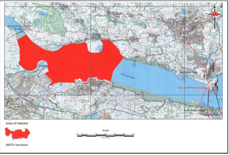
CLNR’s Kincardine licence area

Initially CLNR has been focussing on the Kincardine licence in the Firth of Forth, a coalfield with three former coal-mines including Longannet. The geologist’s report makes interesting reading, and a September 2015 report to potential investors notes that ‘The area contains [a JORC estimate of] 335 million tonnes of coal. The immediately exploitable part of this resource is the energy equivalent of 1.4bn cubic feet of natural gas. To put this in perspective, 1bn cubic feet of gas would meet the energy needs of 11,000 homes for one year.’

Should the Kincardine project go ahead, what would the UCG be used for? It is ‘adjacent to a major petrochemical complex at Grangemouth, the Longannet coal-fired power station and a number of other energy-intensive industries which could benefit from a new low cost source of fuel gas and petrochemical feedstock.’ Fed into Grangemouth, Syngas could be used as feedstock for eg plastics. But there is currently no gas-fired power-station in the vicinity – Cluff is looking into the future.

Syngas is nevertheless a fossil fuel and contains the ‘greenhouse gases’, CO2 and methane. Its use in power-generation only makes sense if carbon capture is employed; Stuart Haszeldine again: ‘Carbon capture is essential to link, and balance between, carbon production and carbon storage [my italics]. Positioning underground gasification in Central Scotland gives easy and unique access to well understood transport pipelines and reliable sites for CO2 storage deep beneath the North Sea.’ (2)  Haszeldine, who is a Director of Scottish Carbon Capture and Storage, is a strong proponent of the idea that CCS should be considered by negotiators at this month’s Paris talks on climate change.

Carbon-capture, pressurised liquefaction and storage on this scale is as yet untried although two demonstration projects – Peterhead in Aberdeenshire and White Rose in Yorkshire, are on track to receive £1 billion UK funding and start construction in 2016.  (The Peterhead project and the ‘empty’ Goldeneye oilwell feature in the third of Ian Stewart’s BBC4 series Planet Oil (from 48 mins in).

CLNR’s plans for the Kincardine Area of Interest have inevitably created concerns and launched protests. A month ago the Scottish Government extended its moratorium on fracking to include another source of ‘unconventional’ gas, UCG , so as to allow the necessary time for “full and careful consideration of the potential impacts of this new technology”.

In response, Cluff has said, ‘It seems to me to be very much a politically-driven issue and not, in my humble opinion, an issue that is in the public interest. … The question you need to ask is what is Scotland going to do after the closure of Longannet takes 40% of Scotland’s electricity-generating capacity out of the system? I would say it’s a very serious situation.’

And what about CLNR’s plans for the Solway Firth?

CLNR's licence area, Maryport and Allonby Bay

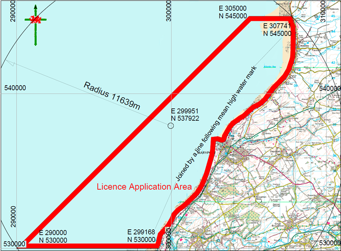
CLNR’s North Cumbria licence area, Maryport and Allonby Bay

CLNR's Whitehaven licence area

CLNR’s Whitehaven licence area

Further details about the Solway licences, including a summary of the survey by geological consultants Wardell Armstrong International, and JORC estimates for coking coal, are in this press release.

UCG plants in the Maryport/Allonby Bay or Workington/Whitehaven areas would require all the onshore facilities mentioned above – for storing water and oxidant, for pressurising the injection, and for collecting and storing and transporting the Syngas. Where would the Syngas be used? Where would the captured and liquified carbon be sent to be stored? (There are of course a lot of ‘big holes’, relics of the industrial past, in West Cumbria.)

Although Scotland is just across the Firth, the UK government is not the same as the Scottish government and has notably different priorities; a moratorium on ‘unconventionals’ is clearly not in the pipeline.

Cluff now plans to concentrate on his English licences instead – there are two off Durham, and two under the Solway. Which of these will be chosen next?

West Cumbria Mining

WCM was set up a couple of years ago, having been awarded several licences covering approximately 200 square kilometres off the Whitehaven coast; early estimates based on existing data suggested there ‘are over 750 million tonnes of coking coal resources across the area’. The exploratory work is being financed with about £15 million provided, in several tranches, by EMR Capital Resources Fund, an Australian private equity company.

WCM's licence areas to the South of Whitehaven

WCM’s licence areas to the South of Whitehaven

When Kevin Murphy, WCM’s Programme Director, gave a talk about the scheme in Cockermouth a few weeks ago, he said that the CEO, Mark Kirkbride, had stressed the importance of an ‘open and honest approach from day 1’, so that the West Cumbrian community would be in no doubt about what WCM intended and were doing. ‘We have lots of engagement with the community, drop-in sessions, meetings,’ he said. And it’s true: you have only to look at their website to see how open the company is to explaining every step of the process and what might be expected or hoped for.
It is, in fact, a model website – articulate, straightforward, well illustrated, with links to community newsletters and updates, all with a friendly tone, that is a delight to browse.

The company has this open and honest approach on its side; Kevin Murphy himself gave a straightforward talk, with none of the smooth business-speak that you might expect. WCM also garners a huge set of advantages in that so much data about the coal seams is already available and, moreover, there seems generally to be a feeling of good will towards a company that wants to re-instate what is essentially the region’s mining heritage. People living in West Cumbria know about coal mines – and they can also appreciate that mining and the treatment of the extracted coal has moved on technically from the Haig Pit days.

There is the ‘potential employment of 400 people, 80% of whom could be local and semi-skilled,’ and Murphy says that Kirkbride is also ‘passionate about this being jobs for local people’; WCM are working with the local colleges, discussing ways of ‘tweaking their courses’ so that they might be able relatively quickly to train, for example, electricians as ‘underground electricians’.

So, what has been happening beside and beneath the Solway?

WCM's sample cores of coal

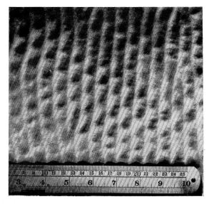
WCM’s sample cores of coal

Phase 1, onshore exploration drilling was completed in 2014: results from four boreholes give an initial JORC estimate of 80 million tonnes onshore of good-quality hard coking coal.

Sample cores and chemical analysis show it has ‘exceptionally low ash, at 3%; low phosphate at less than 0.01% (the usual is ~0.2%); and the sulphur content is moderate – but can be washed out’.


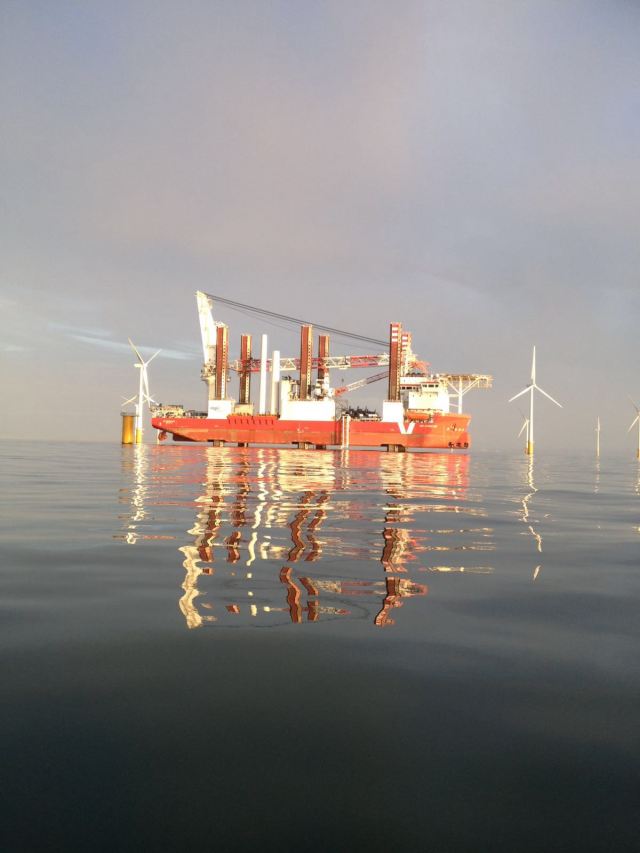
Phase 2 drilling was completed in September 2015, one borehole onshore, and three boreholes offshore beneath a jack-up barge. The coal starts at 350-400 metres and goes down to about 600 metres beneath the sea.

WCM's jack-up barge and drilling rig, South of St Bees' Head

WCM’s jack-up barge and drilling rig, South of St Bees’ Head

Surveys have shown there is a large fault in the way, (‘we need to understand how disruptive this might be’) but otherwise the coal thickens out to sea and is ‘more benign’, in other words shows less faulting than the onshore seams. Of the 13 possible seams, apparently four look useful: Tenquarter, which is ~1.6m deep; Bannock ~2.5m; Main Band ~2.6m; and Sixquarters, ~ 2.0m. There are possibly 1.3bn tonnes of undersea coal in those 4 target seams, enough to supply 2.5m tonnes a year for 50 years (to put this in perspective, Murphy points out that 750kg coking coal makes 1 tonne of crude steel).
By Christmas 2015 WCM must prepare the Preliminary Feasibility Study and outline business case, including preliminary designs for the onshore buildings.

In Phase 3, starting 2016, the necessary permits must be obtained, environmental studies carried out, the Detailed Feasibility (or ‘Bankable’) Study prepared; and another 6 or 7 boreholes drilled.
If all goes smoothly, and all permissions and funding in place, WCM would hope to start constructing the mine in 2018, and start extracting coal by 2019.

What does the mine entail?

The mine will be a drift mine, in other words access will be down a tunnel leading to the unpressurised undersea roads; there will be no vertical shaft with winding gear. The method will be what’s known as ‘run-out and pocket’ pillar excavation, and machines ‘the size of tanks’ will move along hydraulically, cutting and collecting. The coal will be brought out on a conveyor belt.

But a mine doesn’t exist in isolation. The mine-head, the point of entry and exit for the excavations, might be sited in the Whitehaven-St Bees’ valley. On the surface, there will be processing and washing plants – the coal must be separated, crushed and washed to remove sulphur; a large amount of freshwater (source as yet unknown) will be needed to float off the coal. (December 2015: WCM’s newsletter with update on siting, and on waste and water disposal plans is now on their website.)

A storage site is needed – one option being discussed is to site this near the Port of Workington and hence near rail links.

Waste is produced during the tunnelling, and also during the above-ground processing. Murphy talked about the possibility of storing some of the rock waste at the empty mine at Keikle Head. The old anhydride mine might be used for storage: or again, the anhydride mine might be used as a point of access to the new driftmine.

Former miners and local geologists point out that Haig Pit was infamous for the amount of methane gas held in the coal. WCM are aware of this and Kevin Murphy mentioned, in passing, that they might collect the gas and burn it to provide extra energy for the mine.

With regard to steel-making, they would have been able to shift the blame for CO2 production to the coke- and steel-makers; not so with burning methane…

The other  necessity, of course, is transport – of coal and waste.

A digression into railways

WCM made an early commitment that the coal would be moved by rail, and not by road, and they note on their website that ‘the North West coastal railway line passes through the onshore licence block and connects to the nearby Port of Workington and onwards via the UK rail network to the UK’s three main steelworks’.
But the rail line along the county’s western border is currently barely fit for purpose.

Here’s where some joined-up thinking is coming in. Cumbria County Council, as part of the Local Enterprise Partnership’s ‘Cumbria Deal’, have brought companies together that are working on major new projects and have asked them to come up with plans for improving the rail network in the county. Colin Sharpe, Development Manager at the Port of Workington (which has a rail marshalling yard connected to the north-west coast line) told me that the Port, NuGen (proposed new nuclear build), the Environment Agency, United Utilities (new national grid connections), Sellafield (passenger transport for their staff), WCM and others have been asked to ‘sit round the table’ with the rail haulage provider DRS, and overlay the various projects, ‘to look where are the peaks in demand for the railway, where are the gaps, and the pinch-points’. Attention is now focussed on improving the county’s infrastructure.

DRS locomotive being unloaded at Port of Workington, October 2105 (thanks to Colin Sharpe for the photo)

DRS locomotive being unloaded at Port of Workington, October 2105 (thanks to Colin Sharpe for the photo)

(And here, for fun, is a Russian Doll of digressions: two weeks ago a vessel, the Douwe-S, docked at the Port of Workington and unloaded two new locomotives for DRS, the first two of 18, that are being shipped from Spain. They have been hauled away by existing locomotives, and will soon be seen – if you’re interested in looking – working on the wider rail network in the UK.)

Coking coal is metallurgical coal

It’s used for making steel.

Coking coal in steel-making (from WCM's website)

Coking coal in steel-making (from WCM’s website, http://www.westcumbriamining.com/what-is-the-plan/what-is-coking-coal/)

The UK has been importing coal for use in steel-making, 40 million tonnes pa, from America. WCM’s business plan is to partly replace the imports, but also to export coal to European steel-making areas such as the Rhine. WCM’s coking coal would be ‘ideal for boutique shipments’, according to Kevin Murphy.

In light of the cheap steel with which China is ‘flooding the market’, and given that the British steel industry has suddenly suffered a massive collapse – even ArcelorMittal, ‘the world’s biggest steel-maker’ is reporting a loss of £1.3bn for the first 9 months of 2015 – European government ministers have woken up and are gathered together like panicked hens at the steel summit in Brussels, trying to decide what to do.

Without an upturn in the European steel industry, the need for coking coal must surely plummet. Moreover, the price paid for coking coal has also dropped significantly since a high in 2011.

So it will be interesting to hear how WCM’s ‘Bankable Study’ will progress in the coming year.

***

Above the Firth, under the Firth, along the Firth, there are perceived to be many ways of generating electricity: the Solway is a source of many different things, to many different people.

It’s Britain’s Energy Coast-TM; it’s ‘one of the largest undisturbed estuaries in Europe’ (BBC Autumnwatch‘s Michaela Strachan); it’s ‘probably one of the most, if not the most, aggressive estuaries in the UK’ (Colin Sharpe, Port of Workington) ….

If we want it to be these things, and more, then somehow we need to strike a balance. But who is going to oversee this, and how?


(1) JORC: The Australasian Code for Reporting of Exploration Results, Mineral Resources and Ore Reserves, as published by the Joint Ore Reserves Committee of The Australasian Institute of Mining and Metallurgy, Australian Institute of Geoscientists and Minerals Council of Australia

(2) Scottish Carbon Capture and Storage, SCCS.
Research on undersea storage, the CO2 Multistore Joint Industry project, in the North Sea off Scotland, is explained here.


Posted in coal | Tagged , , , , , , , , | Comments Off on What price the Solway’s undersea coal?

Barrages, ‘breakwaters’ and ‘bridges’: three proposals for harnessing tidal power in the Solway Firth

It’s the ‘Energy Coast’ – but where do West Cumbria’s priorities for the county, the country and, more importantly for the long-term future of the planet, lie?
We have onshore and offshore wind power-generation (Robin Rigg), an Anaerobic Digester near Silloth, a Biodigester proposed for Oldside; there are proposals for extracting undersea coking coal (West Cumbria Mining) and for undersea coal gasification (Cluff Natural Resources), a proposed new nuclear power station at Sellafield and, currently, three proposals for generating electricity from the tidal flows in the Solway Firth: a barrage, a lagoon and an ‘electric bridge’.
The UK must deliver 15% of its energy from renewable sources by 2020, under the European Union’s 2009 Renewable Energy Directive. The sea is the ultimate ‘renewable’ source of power: our island is surrounded by an unlimited store of energy carried by the tides and the waves, energy that can be captured by turbines and converted into electricity.

The Solway tides
Let’s look at that energy source with reference to the Solway. The Firth is a finger of water fed by the Irish Sea, and into which, at its inner eastern end, various Scottish and English rivers empty. Twice a day, the sea flows in and out; the volume of river-water varies with the weather.

Proposals for harnessing tidal energy stress the fact that the Firth has a very large tidal range as a selling point. Let’s examine this, too.
The difference in height between high and low tides on the Solway can be as much as 10 metres or as small as about 5 metres depending whether the moon and sun are in alignment (Spring tides) or at right angles (Neap tides); Spring tides have nothing to do with the seasons, as implied in “the chaos of the autumn and spring tides”.

Springs and Neaps happen each month on a predictable cycle – sometimes the Spring tides are especially large as during the ‘supermoon’ phase at the end of September (see below). During the flow of the Spring or ‘big tides’ as they’re known locally, a massive volume of water has to pass up the Firth (and out again) during each approximately 12-hour cycle; the rate of flow is impressive and daunting to experience if you are on the lower shore, and the bore in the Upper Solway near Bowness can be heard as well as seen.

Tidal chart for mid-September 2015 (metres and times)

Tidal chart for end of September 2015 (metres and times) (from the UK Easytide website)

As the tide reaches the innermost point of the Firth, its flow rate decreases and the difference in height between high and low water is much reduced where the sea-water meets the river flow and spreads out over the saltmarshes and mudflats. During low water in the big Spring tides, the only water flowing is from the rivers Eden and Esk (I have walked across the Firth at Bowness at this time).

Tthe end of the viaduct at Bowness on Solway

The end of the viaduct at Bowness on Solway at low Spring tide (photo: Ann Lingard)

So how do you capture ‘Tidal power’?

For clear and informative information about methods of capturing water-borne energy (and other electricity-generating and -storing information) I recommend the Mpower website.

The basic principle of harnessing tidal power is that a proportion of each incoming and outgoing tide is forced to pass across the vanes of a turbine, causing the turbine to rotate against a magnetic field within a generator and produce electricity. The turbine must be bi-directional – it must be able to work with both the ebbing (outgoing) and the flowing (incoming) tide.

Power generation will only occur when water is moving at a prescribed range of flow rates through the turbines – but tidal flow rates are not constant throughout each cycle, there are the periods of ‘slack tide’ each side of the time when the tide turns. The period of generation is thus between 6-10 hours, depending on the location.

This can be improved by trapping some of the water and releasing it, so that the available energy depends on the head of the water above a turbine and the volume of water flowing through it. If the tidal flow is constrained by walls such as a barrage or a lagoon, water-levels can be controlled via gates and overflows to provide a manageable flow rate through the turbines.

With a lagoon, some of the sea is trapped within an enclosed space while the rest of the main tidal flow passes by outside; with a barrage across an estuary, the tide must pass via the turbine spaces and also, presumably, gates built into the wall.

What does building a ‘tidal power’ generating system require, with reference to the Solway?

Turbines, obviously – which need to be set in a supporting framework, which might be a rigid wall or barrage; a generating system; transformers – which might be installed nearby (as in Robin Rigg offshore windfarm); cables to transport to the shore the electricity generated; onshore control centres and support systems; links to the National Grid with the Grid having the capacity to carry the electricity generated.

Walls – barrages, lagoons – need foundations on the sea-bed so, since large areas of the Solway’s bed are very labile and changeable, bathymetric and geological surveys are obviously necessary. Walls need cement, and boulders or baffles to dissipate the power of the sea during storms. For rocks/boulders you need a large source of stone. Also vital is the infrastructure for transport, via the sea (the Port of Workington, conveniently placed as a ‘logistics hub’) and road and rail.

There is also local shipping to consider – ranging from tankers and other merchant vessels visiting the ports of Workington and Silloth, to trawlers, windfarm support vessels and pleasure yachts visiting or working out of Whitehaven and Maryport – which needs access via sea-locks.

Another requisite which is rarely mentioned, is an understanding and modelling of the potential effects of altering the currents, and of the building process itself, on the erosion and deposition of sediment.

And a final requisite is serious, dispassionate thought about what is valuable about the Solway Firth and what we, as the human species, ‘want’ from it.

The three proposals
1. NorthWest Energy Squared (NWE2) model

Map of the NWE2 scheme (from their website)

Map of the NWE2 scheme (from their website)

The aim of the scheme, supported by the North West Business Leadership Team (NWBLT) is to build a series of ‘tidal gateways’ across the estuaries on the west coast linked by a dual carriageway. These tidal gateways – actually barrages – would be built across the Dee, Mersey and Ribble estuaries, Morecambe Bay and the Solway Firth.

The themes are power-generation and ‘connectivity’.

The latter involves improvements – dual-carriageways – for the road system from the North Wales coast road to Stranraer, with additional roads across the tops of the barrages. This would reduce road transport times along the system and beyond: for example, from Workington to Stranraer would be reduced by about 70 minutes. Improvements to the A595 road up the west coast of Cumbria could ‘add a further 7 million tourists to the 35 million who already visit the region, providing a much-needed boost to the local economies of places such Whitehaven and Maryport’. It is also suggested that the scheme would help in flood control, ‘as the gateway could help mitigate flood risk suffered by Carlisle’.

The Kirkcudbright-Workington ‘gateway’ would be 30 kms long and create around 3600 construction jobs per year for 10 years. As for power-generation, it’s estimated that the Solway scheme would generate 8.44TWh (8440 million kWh) per year, power for nearly 2 million homes.

NWE2 model at The Beacon, Whitehaven

NWE2 model at The Beacon, Whitehaven (photo: Ann Lingard)

NWE2  is based in Manchester and its chairman, Alan Torevell, approached Arup with the idea of creating a computer-generated 3D model which, with a video, was on show at The Beacon, Whitehaven, in May.

The Solway Firth 'gateway' on NWE2's model

The Solway Firth ‘gateway’ on NWE2’s model

How Arup came to design the model is explained in detail on page 8 of The Times’ Business Insight North, June 2014. Unfortunately only the 3D-printed, physical model of the North-West was available at The Beacon. This was a shame though understandable – but with the complementary digital and interactive model, images can apparently be projected and overlaid on the physical model, and a touchscreen should ‘allow visitors to gain further information and answers to questions such as “What will be the impact on the mudflats of a specific estuary due to a tidal gateway?” ’

What indeed? According to Alan Torevell, in an interview on pages 6 and 7 of the same issue of Business Insight North, potential financers such as pension and insurance companies ‘ “won’t make any investment until they know the Government is going to have the conditions in place, that they are not going to be held up for 10 years by birdwatchers…”.

alan torevell the times cover

Alan Torevell on the cover of The Times’ Business Insight North

The article quotes his ‘simple message for the environmentalists: tidal gateways won’t harm birds… the reality is it won’t disturb the birds. “There will be environmental problems during construction, but not a lot and they will still keep going there. The main argument is about high and low tide levels and the way it impinges upon the mudflats… But the gateways aren’t going to change the fact that the tide will still come in and go out as normal. So why should we worry about the birds if we are not doing them any harm?” ’

As for shipping, there was no mention of that on the video but Deb Wheeler, who was on hand to explain the physical model at The Beacon, told me that sea-locks would be included.

2. Tidal Lagoon Power

(Update, January 18th 2016: questions raised about bi-directional efficiency of the turbines, and the effect of turbulence.)

Tidal Lagoon Power, under its ‘fast-talking and ebullient’ CEO Mark Shorrock (as Terry Macalister describes him in a Guardian report)  has plans to build 6 tidal lagoons, one of which would be in the Solway Firth, from Workington to Dubmill Point at the north end of Allonby Bay.

Artist's impression of the Swansea tidal lagoon

TLP’s proposed Swansea lagoon

At present, all the emphasis is on the first lagoon, a 9.6 km (~6 miles) ‘breakwater’ with 16 turbines in Swansea Bay. It is expected to generate 500GWh of power by 2019, enough to power 155,000 homes for 120 years. It would also, according to an article by the Landscape Institute, provide ‘a major sports, tourism and leisure destination, contributing to local regeneration,’  with landscaping and a visitor centre.

Artist's impression of the Swansea lagoon

Artist’s impression of the Swansea lagoon

Amongst the appointed contractors  are Laing O’Rourke and Arup for the turbine housing and sluice gates,  Atkins for design engineering, General Electric UK for the turbines, and the China Harbour Engineering Company for building the wall.

TLP had hoped that all the permissions and the price for the electricity would have been finalised by this autumn, so that work could begin, but now this is unlikely to happen until August 2016 for two main reasons. One problem is the negotiation with the Department for Energy and Climate Change (DECC) over the Contract for Difference, which sets out the price over a fixed period that will be paid to a power-generating company for its electricity. The ‘strike price’ that TLP is seeking, of £168/MWh for 35 years is very much higher than the £92.50 strike price for the proposed nuclear reactor at Hinkley Point. In mitigation, TLP says its five future lagoons will be larger, apparently benefitting from economies of scale (although the major part of the cost, the cost of building each kilometre of wall, will presumably be roughly the same) so that a strike prices of less than £100 might be possible by the third lagoon – in other words, TLP is treating its six-lagoon scheme as a package.

There was also allegation that the tendering process for building the wall had ‘been awarded improperly’ to the Chinese company.
But the most recent news is that the Chinese company state that the cost of building the Swansea wall has been greatly underestimated – and thus TLP would require an even higher strike price from the government.

In the light of these setbacks, TLP have recently stated (see for example, the ‘Events‘ section and their Twitter account, @TidalLagoon) that the whole process has been deferred for a year until autumn 2016, with building to start in 2017.

The engineering challenges
Ignoring all that for a moment, let’s consider what building a lagoon and retaining wall entails, in a place where there are 4 tidal flows a day. If you look at the construction in terms of its engineering, it presents interesting challenges.

Cross-section through the wall, from Constrcution magazine

Cross-section through the lagoon wall, from Construction-manager website http://www.construction-manager.co.uk

The Swansea wall – ‘breakwater’ is a euphemism, the lagoon is essentially a U-shaped dam – will be 9.6km long, 5 m high at the onshore end and 20 m high further out, of which up to 12 m will show at low tide. According to the article in Construction Manager, ‘First, two  metre-high barrier walls of “quarry run” – randomly shaped stone – are laid parallel under water with the space between them filled with sand. Further progressively narrower layers of rock and sand are placed on top of the construction until a barrier with a triangle-shaped section is formed. Larger “rock armour” is then positioned on top of the structure to protect it from the sea.’ And the whole is topped-off with a concrete road.

Where the rock will come from is currently a matter of controversy, especially amongst Cornish residents along the Lizard Pensinsula (Cornwall Against Dean Superquarry), where Shire Oak Quarries, a company headed by TLP’s CEO Mark Shorrock, has plans to turn an existing coastal quarry into a ‘super-quarry’ complete with jetties.

It is estimated that 7 million tonnes of sand will be dredged from Swansea Bay, probably from within the lagoon area, to infill the rock walls.

There is a detailed treatment of concerns and possible remedies for the impact on the marine life within the lagoon and during construction in the Planning Inspectorate’s report and recommendation (from p136, section 4.13.55, for example). For example, research is being carried out at the University of Swansea on the feasibility of translocating the reefs built by the honeycomb worm, Sabellaria (similar reefs are also found in the Solway’s Allonby Bay).

How this type of lagoon would affect the Solway Firth will very much depend on the final site and length. The current proposal, for a 31km wall from Workington to Dubmill Point (and thus across the proposed Marine Conservation Zone in Allonby Bay) would contain 90 turbines.

Regarding TLP’s plans for the Solway Firth, Lisa Jenkins, part of the TLP communications team, told me in May that the West Cumbria project was at too early a stage to give me any details, the company was working on ‘very initial feasibility studies’, there were no formal consultations as yet, but they ‘were really encouraged by the enthusiasm shown within the area’. Roger Woods, TLP’s Development Director for West Cumbria, reiterated this in an email. The website is uninformative.

Might there be a Plan B for a smaller lagoon based around Workington, should DEFRA approve Allonby Bay as a Marine Conservation Zone? (Might DEFRA be persuaded that Allonby Bay is an unsuitable candidate? We must await the outcome of their consultation process, due January 2016.)

Preliminary meetings have been held with Allerdale councillors and with Britain’s Energy CoastTM. One councillor told me he was ‘quietly optimistic’.

But since the future of the Swansea lagoon is looking uncertain, the prospect of a Solway lagoon is looking more uncertain still.

It would be nice to know what is happening.

3. Solway Energy Gateway, SEG
In 2009 Halcrow, Mott McDonald and RSK published an interesting and detailed study of the bathymetry, tidal flows and many environmental facets of the Solway with the aim of assessing the feasibility of various methods for generating tidal power; the methods included barrages, lagoons and ‘fences’ at different locations within the Firth (see Slide 11 of SEG’s presentation).

Out of this grew the idea for a power-generating system at position B3/R3 on the above-mentioned slide, and Solway Energy Gateway Ltd, a ‘local company committed to a sustainable and ethical business model’, was founded and chaired by Nigel Catterson (who is the current Chairman of Britain’s Energy Coast and has strong involvements with other ‘green’ projects including ‘Utropia’ at Broughton Moor near Cockermouth).

Neither a barrage nor a lagoon, the ‘electric bridge’ would also provide a route for pedestrians and cyclists between England and Scotland, at the site of the vanished Annan-Bowness viaduct. Rather than standard turbines, the bridge would incorporate VerdErg’s Venturi Enhanced Turbine Technology (VETT) and would be able to generate ‘about 160MW (megawatts), with a consistent output of about 29MW or 245GWh … enough to power about 76,000 homes’.

The basic priciples of the VETT (formerly known as SMEC) turbine

The basic priciples of the VETT (formerly known as SMEC) turbine

The VETT, which can work in low water levels by increasing the ‘head’ of pressure that drives the turbine, and which uses only 20% of the water passing through – the other 80% by-passes the turbine – has been used in small field trials. The only moving part in the structure is the actual turbine, so the system is cheap to install and run. Another trial using 900 fish showed that none were damaged by passing through the VETT; this would be especially important at the Annan-Bowness site because salmon pass through this narrow neck of the Firth to breed in the Esk and Eden.

At present, the VETT system works only in one direction; VerdErg are currently working with Arup to design a bi-directional turbine and Nigel Catterson tells me that the testing will finish at the end of March 2016 and that the evidence that the bi-directional device will be as efficient as the unidirectional device is ‘very encouraging’.

Arup have also recently used a drone to make useful aerial surveys of the Firth at the site of the ‘bridge’ (the images will soon be on the SEG website – they will probably be much better quality than my own, taken from the gyroplane!).

The length of the proposed ‘bridge’ would be very much less than the walls required in the barrage and lagoon proposals, and much cheaper to build – in the region of £300-400 million. Although the design has not yet been finalised, Catterson says it can be thought of as a ‘movable weir’ that can be raised or lowered by bladders of water or air according to the state of the tide; on top of the row of VETTs will be a plate that can be angled so as to focus and regulate the tidal flow through the orifices that contain the turbines.

It will be necessary to excavate the sea-bottom to reach the bedrock, so that the systems can be firmly anchored; slabs will be installed in the base of the estuary and above them ‘will rise the pillars of an elegant-looking bridge’ for cyclists and pedestrians.

From the Solway Energy Gateway's workshop, Dumfries

From the Solway Energy Gateway’s workshop, Dumfries

SEG are committed to involving the communities on each side of the Firth, and Catterson held a Dumfries workshop in May under the auspices of the Solway Firth Partnership to gather opinions and find out what people wanted from the project: the responses are summarised in this presentation.

The system would apparently qualify for DECC’s Tidal Stream Payments (similar to that offered for the MeyGen underwater turbine scheme in the Pentland Firth) which offers a high strike price of £305/MW; but ‘even at half that strike price, the scheme would be paid for in 10 years’. SEG has also received interest from potential investor companies including pension funds. And Nigel Catterson tells me he is still aiming on 2020 for the electric bridge to start generating power.

*****

I have deliberately avoided discussion of the effects, on the people and the life and functioning of the Solway Firth, of harnessing the power and energy of its tides.

All I have tried to do here is present the background and some of the facts about the three proposals. It’s early days – untried technologies, questions about construction, about prices, and in some cases a lack of ‘transparency’ – but if we want to get away from our dependency on fossil fuel, the power of the tides is (eventually) there for the taking. It’s how we do ‘the taking’ that must concern us too.

Posted in renewable energy, tide & wind, The 'Energy Coast' | Tagged , , , , , , , | Comments Off on Barrages, ‘breakwaters’ and ‘bridges’: three proposals for harnessing tidal power in the Solway Firth

Snippets 6: ” ‘Tis the voice of the lobster’ I heard him declare…”

The Aquarium (at low tide)Cumbria isn’t just about the National Park and Herdwick sheep, but even on the Solway coast, it sometimes helps to have ‘Lake District’ in your title. The Lake District Coast Aquarium at Maryport is a little gem of an aquarium in a perfect setting: trawlers moored in the harbour, views over the Firth to Scotland, a fish-shop that sells the local catch. And inside the aquarium, many of the tanks are set up as local habitats with local fish and invertebrates, ranging from conger eels to plaice to pipe-fish and beadlet anemones, to whelks and sponges and brittle-stars. Paul Sloan, chief aquarist and an enthusiastic shore-walker, and his colleagues have also had success in raising sea-horses and jellyfish. Periodically a wave crashes through a large tank of fish, and you can even hang over the tank of skates and flatfish and dogfish to ‘stroke a thornback ray’. The lighting is dim, the floor is damp, and the interlinked rooms smell of the shore.

But back in July a bright new extension, the Sea Lab, was opened, partly paid for by Cumbria Fisheries Local Action Group, FLAG. Amongst the treats such as a dome in which you can sit and be surrounded by fish, and microscopes for seeing high-power detail of plankton and algae, there is the lobster hatchery.

The lobster hatchery in the Sea Lab

The lobster hatchery in the Sea Lab

For very young lobsters, the sea is a dangerous place and a high proportion are lost during early life. But they spend the first 8-9 months of their lives safely attached to their mother.

A berried hen lobster (photo from the NHL's website)

A berried hen lobster (photo from the National Lobster Hatchery’s website)

Through the autumn and the winter, the ‘hen’ lobster broods her basket of eggs, as bright as crowberries, under her tail, tucked in beneath her swimmerets. Inside the eggs, the embryos go through early development stages such as the delicate transparent nauplius (the nauplius stage is also passed through by crabs and even barnacles.).
The lobster’s first-stage larvae, the L1s, eventually hatch and are released into the water to survive as best they can, feeding, and moulting three times until they reach the L4 stage. Now, finally they are starting to look like mini-lobsters, and at this stage they drop down to the bottom of the sea, each excavating a burrow in which it can hide and feed and grow. From now on it will lead a benthic, crawling, life.

If a lobster can survive to this stage it has a much-improved chance of surviving to adult-hood – and it’s the aim of the aquarium’s staff to get them through those early months before releasing them into the Firth.

Paul showed me how the hatchery worked. There was a hen lobster in the tank, but she was soon to be released because her eggs had hatched. ‘We’ve had six or seven hens over the summer,’ Paul told me. ‘The local fishermen bring them in and we keep them in the tank until their eggs hatch.’

The hatching tank - larvae swim up and are taken off from the top

The hatching tank – larvae swim up and are taken off from the top

Because the larvae, which are only 1-2 mm long at this stage are planktonic, they tend to swim up to the surface where they can be drawn off into a separate tank and then into conical containers. During this time they’re fed, and the water in the tanks is constantly circulated, aerated and filtered to reduce build-up of bacteria and protein ‘froth’.
The speed at which the larvae grow and develop is dependent on the water-temperature – and at 15-18 degrees C it takes about 6 weeks, Paul said, before the larvae moult to L4 and can be moved on.

Now they’re about 5mm long and brown and it’s easy to see their long front legs with pincers. They’re also very predatory – and because any other sibling is seen as potential prey they are separated off into individual compartments in special trays.

Stage 4 larvae in a hive tray

Stage 4 larvae in a hive tray

From there, it’s off to the hive! The trays are stacked within the circulating water column and each L4 eats and grows and moults; there are three moults within about 2 weeks, and the newly-moulted animal eats its cast skeleton – after all, it’s a good source of protein and minerals. Meanwhile, Paul and his assistants are feeding all the larvae three times a day with a ‘soup’ of other planktonic crustaceans, the copepod Calanus.

Paul feeding the hive with the Calanus 'soup'

Paul feeding the hive with the Calanus ‘soup’

The baby lobsters will stay in the hive system for 2-3 months before being released into the Firth.

There are various plans for how best to release the new stock. Divers might take a stack of trays and release the lobsters on the bottom; or containers – covered by a thin tissue membrane – might be dropped within lobster-pots. When I spoke to Paul in early October, these details hadn’t been finalised with North-West IFCA but he was hopeful that releases would occur very soon.


Update, June 2018

It’s always a pleasure to visit the aquarium in Maryport, there’s always something new and interesting. Today the two conger eels had partly emerged from their ‘caves’, and the size and thickness of their bodies was all too apparent.

IMG_6077

In the Lobster Hatchery, young thornback rays, speckled pale brown, circled their tank or flattened against the sandy bottom. They had hatched from eggs laid last August by adult females in the large tank, the ‘touching tank’ where you can reach in and ‘stroke a ray’.


In the Lobster Hatchery itself is a display of photos recording the licensed release of young lobsters last August into the Firth near Ravenglass ‘where they were conceived’.

As Paul had described to me previously, the baby lobsters were tipped from their hive trays into a plastic container, then poured into the release hopper, and thence into a weighted hose that deposited them on the sea-bottom as the boat drifted.

The site had been chosen for the cover of kelp that would provide a safe haven for the small and still-vulnerable creatures. More than 1000 young lobsters were released last year, and the Hatchery continues to do well: three new ‘berried’ females are due to arrive to supply the necessary eggs for this year’s rearing and release.

Posted in conservation, fishing, Snippets | Tagged , , , , , , | Comments Off on Snippets 6: ” ‘Tis the voice of the lobster’ I heard him declare…”